NASA Says El Niño Is on Track to Become One of the Strongest on Record
NASA satellite observations reveal an unusually powerful El Niño developing across the Pacific Ocean, with scientists warning that the climate phenomenon could disrupt rainfall patterns, intensify extreme weather and contribute to rising global temperatures through early 2027.

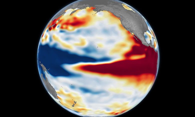
NASA has reported that a powerful El Niño event is developing across the tropical Pacific Ocean, with satellite observations revealing patterns similar to some of the strongest events recorded in modern history. In an update published in October 2026, the space agency explained that unusually warm ocean water is spreading across the central and eastern equatorial Pacific, changing sea levels and influencing atmospheric circulation. The National Oceanic and Atmospheric Administration (NOAA) has estimated an 83% probability that the event will become the strongest El Niño since records began in 1950. Scientists are monitoring the situation closely because powerful El Niño events can affect weather conditions across multiple continents. However, the exact consequences will depend on how the event develops and how the atmosphere responds to the changing ocean temperatures.
El Niño is a natural climate phenomenon that occurs when sea surface temperatures in parts of the equatorial Pacific become warmer than normal. The warming weakens or changes the usual trade winds, allowing warm water and atmospheric circulation patterns to shift across the ocean. These changes influence where clouds form and where rainfall occurs, sometimes producing drought in one region and heavy rainfall or flooding in another. El Niño typically develops every two to seven years, although its strength and duration vary considerably. The current event is attracting particular attention because the temperature differences across the Pacific have become exceptionally large. According to the International Research Institute for Climate and Society, the weekly Niño 3.4 sea-surface-temperature anomaly reached approximately 3.3°C in mid-October 2026, indicating a very strong event.
NASA is using satellite measurements of ocean temperature, sea-surface height and other characteristics to monitor the phenomenon. Warmer ocean water expands, causing sea levels to rise in affected areas, while changes in ocean circulation alter the distribution of heat across the Pacific. NASA’s October 23 comparison of satellite observations from 1997 and 2026 showed similarities between the current pattern and the powerful El Niño that developed in 1997–1998. That earlier event was associated with major disruptions to weather patterns around the world. Scientists caution, however, that similarities in ocean conditions do not guarantee identical outcomes. The atmosphere is highly complex, and regional impacts depend on several factors beyond the strength of El Niño alone.
The expected consequences include changes in rainfall, temperature and the frequency of certain extreme weather events. Some regions may experience prolonged dry conditions, increasing the risk of drought, crop losses and water shortages. Other areas could face heavier rainfall, flooding and landslides. El Niño can also contribute to higher global average temperatures because it transfers additional heat from the ocean into the atmosphere. The World Meteorological Organization reported in October that the current event was expected to intensify and potentially peak around December 2026, with impacts continuing into early 2027. Nevertheless, El Niño does not determine every weather event, and its influence varies by region and season. Local forecasts remain essential for understanding the specific risks facing individual communities.
Scientists say continued monitoring will be essential as the event develops over the coming months. Governments, agricultural organisations, emergency services and water-management authorities can use seasonal climate forecasts to prepare for potential disruptions. Farmers may need to adjust planting schedules, while communities vulnerable to flooding or drought may benefit from early-warning systems and contingency planning. For countries in West Africa, including Nigeria, El Niño’s effects are not automatic or uniform; regional rainfall forecasts should be consulted before drawing conclusions about local weather conditions. Although the current event could rank among the strongest on record, scientists stress that its precise impacts remain uncertain. NASA’s satellite observations will help researchers understand how the Pacific is changing and improve forecasts of the climate risks associated with this major event.